
Olympia ZIP Directory Coverage
Official county material identifies several Olympia-labeled delivery areas plus adjacent Thurston County post offices. The table separates ordinary delivery ZIPs from special labels. It should not be read as a city-limit map. Use the USPS ZIP Lookup for a current mailing result and county parcel data for jurisdiction.
| ZIP Code | Areas Covered | Post Office | Notes |
|---|---|---|---|
| 98501 | Core Olympia delivery | Olympia Main | Verify each address with USPS |
| 98502 | West and central Olympia delivery | Olympia | 2019 notice links its label history with 98599 |
| 98504 | Washington State Agencies | Institutional | Not a residential neighborhood polygon |
| 98505 | The Evergreen State College | Institutional | Does not identify each person at the institution |
| 98506 | Olympia delivery area | Olympia | Confirm street and jurisdiction |
| 98507 | Post-office association | Olympia Main | Verify a delivery point |
| 98508 | Olympia-area delivery | Olympia Westside | Postal label, not a city boundary |
| 98512 | South and east Olympia label | Olympia | Can include unincorporated county |
| 98513 | Olympia and county fringe | Olympia | Exact location needs parcel check |
| 98516 | North and east growth area | Olympia | City-status mismatch is possible |
| 98599 | Special or legacy destination | Olympia | Check current USPS label |
The broader county map also labels 98503 and 98509 for Lacey, 98511 for Tumwater, 98540 for East Olympia, 98556 for Littlerock, 98530 for Bucoda, 98576 for Rainier, 98589 for Tenino, and 98597 for Yelm. Those places may matter to a metro-area search, but none should be silently folded into an Olympia resident count.
Olympia's Institution ZIP Codes
Two labels stand out on the county map. ZIP 98504 is assigned to Washington State Agencies, while 98505 identifies The Evergreen State College. These are institutional postal tools, not ordinary neighborhood shapes. Searching either as though it were a block can create false assumptions about who lives there. A listed institution address can be tied to mail handling without showing a person's home.
This geography is the strongest Profile 3 interest feature for Olympia because it shows how a city label can describe a large institution rather than a residential community.
Find Olympia Residents by ZIP
No confirmed public ZIP filter was found in the A+ parcel form, VoteWA, or Olympia SmartGov. A sound ZIP code directory workflow therefore starts with postal verification and map geography, not a promise of a one-click resident list. The public voter extract can be requested by county, while ZIP and precinct boundaries remain different systems.
- Enter the full street in USPS By Address and save the current postal ZIP and city label.
- Query the Thurston ZIP layer for the ZIP polygon, then compare the point with parcel city status.
- Use A+ by exact address or street name to identify a parcel. Do not infer occupancy from the taxpayer mailing line.
- If election geography is relevant, compare district or precinct mapping separately because it does not follow ZIP lines.
Once a postal area narrows the search, the Olympia street directory explains the street-level address chain. It keeps a broad ZIP result from being mistaken for a named block.
Verify Olympia ZIPs With USPS
USPS provides three distinct modes: By Address, By City & State, and Cities by ZIP. By Address accepts a street plus city and state, or a street plus ZIP; it also shows an optional company field. The result validates postal addressing. USPS expressly does not confirm that a person or company is present at that address.
| USPS mode | Best Olympia use | Limit |
|---|---|---|
| By Address | Confirm the current delivery ZIP for one street address | Does not verify a resident |
| By City & State | List ZIPs associated with an Olympia city label | Does not map city limits |
| Cities by ZIP | Check accepted postal city names for one ZIP | A label can cover county fringe or an institution |
The manifest's USPS screenshot failed and is omitted. The live official tool remains the right source because delivery labels can change after a static county map was published.
Query Thurston's Olympia ZIP Layer
The Thurston County ZIP ArcGIS layer exposes fields named ZipCode, Name, ZipType, and NameType. It supports public queries and output in JSON, GeoJSON, or PBF, plus statistics, paging, and distance options. The layer describes federal post-office ZIP areas derived from older USPS TIGER data tied to the 2000 Census. It is useful for map comparison, but not the last word on a current delivery point.
Inspect the official Thurston ZIP layer shown below.
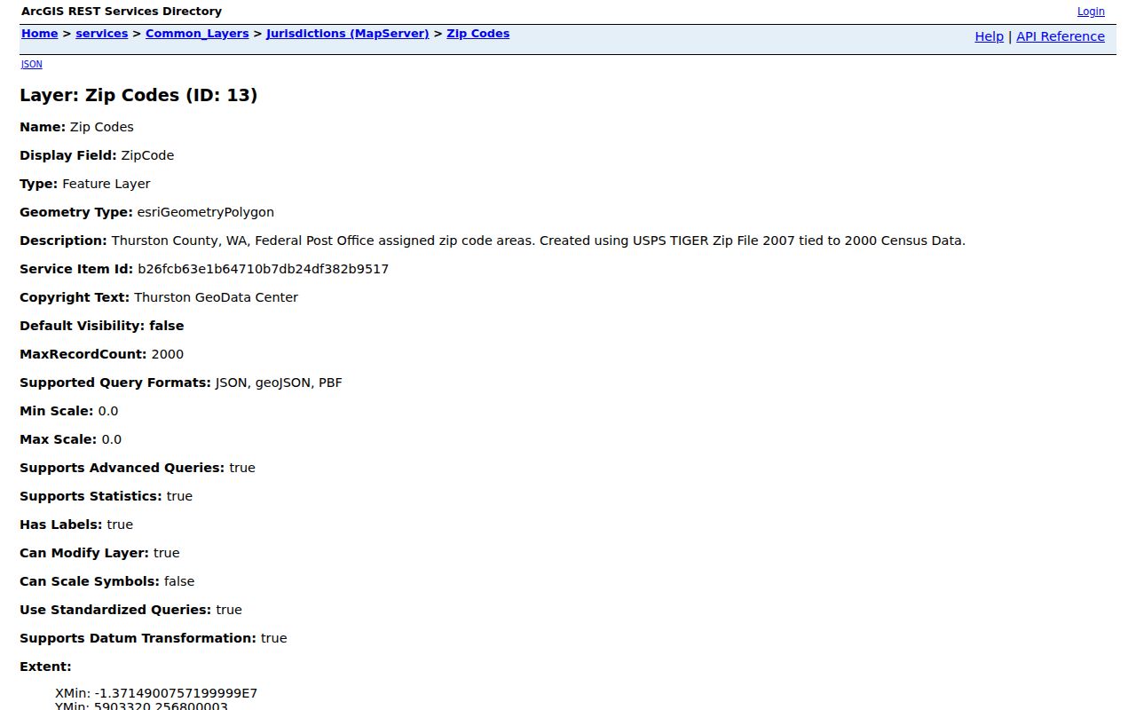
The service fields distinguish ZIP code, place name, and type. Pair that mapped shape with USPS By Address whenever age or a boundary edge could change the result.
Note: The official county ZIP map PDF capture failed, so no image from that manifest row is displayed.
Check Olympia Parcel City Status
A postal label answers where mail is routed. The parcel record answers a different question. Thurston's A+ Parcel Search accepts an 11-digit parcel number, owner or taxpayer name, a complete address, or street name only. Its output can show the parcel number, situs address, ZIP, mapped boundary, and city-versus-unincorporated status.
Use the situs address, which is the property's physical location, for map comparison. A taxpayer mailing address may be elsewhere. The legal description identifies land by plat, lot and block, or metes and bounds; it is not a postal address. Sorting street results by address can help, but the portal does not document a ZIP-wide search.
Olympia's 98599 Label Change
A 2019 USPS Postal Bulletin records a destination relabeling relationship involving 98599 and Olympia 98502. That is evidence of postal history, not proof that a physical boundary moved. Old mail, directories, and databases may preserve the former destination label after current delivery systems use another one.
When the same street appears under both codes, verify the address in the live USPS tool, record the date checked, and compare any historical source using the label printed at the time. This keeps a postal update from becoming an invented move by an Olympia household.
Olympia ZIPs Meet Nearby Labels
East Olympia, Littlerock, Bucoda, Rainier, Tenino, and Yelm appear as separate post-office labels in county material. Lacey and Tumwater have their own labels as well. These names describe postal geography across connected Thurston County, not annexations into Olympia. A person searching an old classmate or relative should test the exact street and source date instead of assuming that every metro-area name belongs in one Olympia ZIP code directory result.
Directory history makes this point concrete. Olympia volumes listed Lacey in 1974-1982 and Tumwater in several early runs plus later years through 2012. A historical publisher could group places for sales and reference purposes, while USPS and local government drew different lines. The printed heading, postal code, parcel jurisdiction, and directory year must each be preserved as separate evidence.
Olympia ZIPs, Precincts, Neighborhoods
Election precincts and recognized neighborhood associations do not follow ZIP boundaries. Washington's voter-file request offers county selection and can include address, year of birth, voting history, district, and precinct fields under legal limits. It does not document a public ZIP-filtered web search. If the purpose is lawful civic research, request the proper county file and analyze its stated fields rather than treating a ZIP polygon as an election district.
The City of Olympia recognized-neighborhood program also covers city and urban-growth-area relationships. Its public directory concerns association contacts and status, not a private membership list. County GIS layers can place these boundaries beside postal geography, but each layer answers a distinct question. A ZIP identifies mail service, a precinct organizes elections, and a neighborhood group reflects civic participation.
For a repeatable comparison, save the full address, the USPS result date, the GIS layer name, and the parcel number. If the sources disagree, give more weight to current USPS delivery data for mail and to the county parcel map for local jurisdiction. Neither result alone confirms who occupies the address.
Keep older ZIP evidence with its date. Postal labels, maps, and directory coverage can change at different times, so an undated code is weak proof in family-history research.
Olympia ZIPs Versus City Limits
Olympia's municipal line, urban growth area, recognized-neighborhood boundaries, election precincts, and ZIP areas do not match. A parcel may carry an Olympia ZIP while lying in unincorporated Thurston County. A nearby Lacey or Tumwater label may appear within the same broader resident search. Historical directories add their own coverage choices, sometimes including Lacey or Tumwater under an Olympia volume.
- ZIP code
- A postal delivery area or label; it is not a municipal boundary.
- ZIP+4
- The base ZIP plus four digits that narrow mail routing to a smaller delivery segment.
- PO-box ZIP
- A code used mainly or solely for post-office boxes rather than a neighborhood.
- Unique ZIP
- A code assigned to a large organization or institution, such as a state agency group or college.
- Carrier route
- A postal delivery path within a ZIP, which may cross other civic boundaries.
For a careful Olympia ZIP code directory result, record three facts separately: the USPS mailing label, the county parcel's city status, and the source date. That small habit prevents a postal area from being treated as proof of residence or jurisdiction.